GIS for Homeland Security - Fall 2016 @ Chicago State University
Course Development for GEOG 5XXX
Course Information
Course Name: GIS FOR HOMELAND SECURITY
Class Meetings: Fully online
Required Textbooks: 1) Mastering ArcGIS (6th or 7th edition) , by Price
AND
2) GIS for Homeland Security , by Kataoka
Course Description: Introduction to geographic information systems (GIS) and homeland security; spatial data acquisition and database development; data quality and standards ; visualizing, compiling, and analyzing spatial data for homeland security planning and operations (preparation, prevention, protection, response, and recovery scenarios); designing map layouts for homeland security planning and operations.
Course Purpose: Develop critical thinking, technical, and communication skills regarding spatial analysis using GIS in general, and how to apply those skills to issues of homeland security in particular.
Learning Outcomes & Course Objectives
LEARNING OUTCOMES ADDRESSED BY THE COURSE:
CA5: Intelligence Analysis
CC2: Critical Thinking
CC5: Communication
CC6: Technical Expertise
CC7: Subject Matter Expertise
COURSE OBJECTIVES
CO#1: Introduce students to the fundamental concepts of GIS and real-world representation, using GIS raster and vector spatial data input, topology, cartographic projections, and coordinate systems.
CO#2: Explain vector and raster data models and demonstrate competence in managing and integrating vector and raster data models for GIS analysis and modeling.
CO#3: Download vector and raster data in different formats and projections from various sources, including the Internet, and create a GIS database for GIS analysis and modeling.
CO#4: Apply functionalities and analytical capabilities of ArcGIS for desktop and ArcGIS online for data analysis and modeling.
CO#5: Apply GIS principles and techniques for analyzing data for homeland security planning and operations.
Assessment
NOTE: The differences between the 4XXX and 5XXX classes are highlighted in red below.
Course Requirements: Students should complete 10 lab exercises and participate in 10 online discussions about GIS issues. In addition to the lab exercises and online discussions, students enrolled in GEOG 5XXX should submit a final project evidencing their ability to download data, create a database, map and analyze an issue related to homeland security using the tools, theories and applications learned during the semester. A list of approved sources will be provided. Two equally weighted exams will be given during the semester: a midterm and a final. The exams will consist of definition of terms, computations, and essay questions and there will be a review guide provided for each exam. The final exam will not be cumulative.
Lab Exercises................................. 30%
Midterm Exam ...............................15%
Final Exam ..................................... 15%
Online Discussions .................... 20%
Final Project .................................. 20%
Schedules
NOTE: The differences between the 4XXX and 5XXX classes are highlighted in red below.
GIS for Homeland Security 4XXX (Undergrad Students)
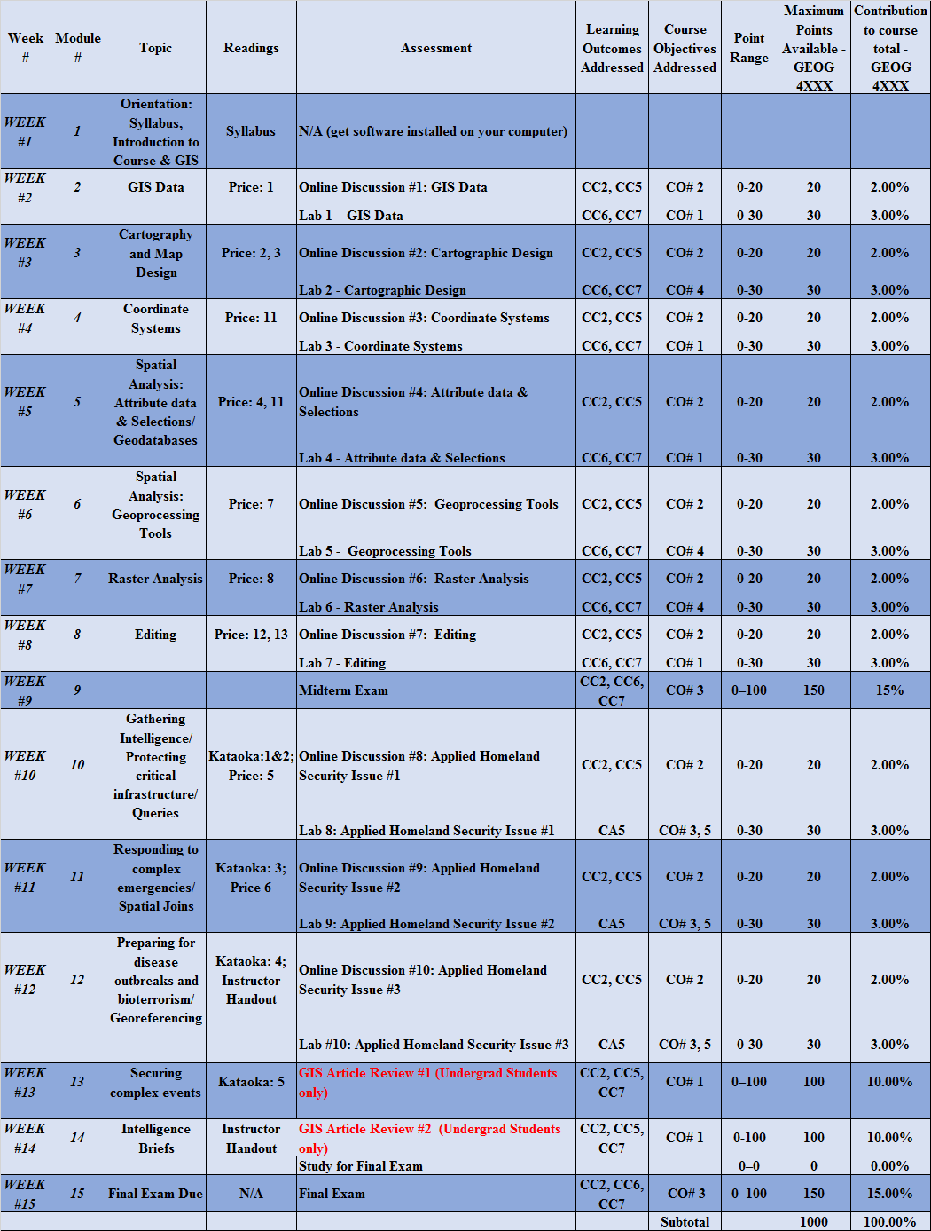
GIS for Homeland Security 5XXX (Grad Students)

Example Module - Module 2
The purpose of Module 2 is to introduce students to the ArcMap software environment as well as to foster communication amongst students. Specifically, upon completion of the module, students will learn how to 1) explain the difference between vector and raster data models, 2) summarize concepts and common operations pertinent to raster and vector GIS, 3) discuss the differences between raster and vector GIS data as well as the comparative advantages and disadvantages of each, and 4) describe the difference between discrete and continuous data.
THERE ARE FOUR TASKS FOR Module 2:
1. Watch the Module 2 Overview video (see below - about 16 minutes)2. Complete Lab #1 and answer the questions asked during the lab. Lab instructions can be downloaded here. (20 Points total - awarded per correct question)
(Note to course development team: The lab instruction pdf is provided here above since you probably do not have the textbook, but the instructions come from pp. 26-39 of the Price text.)
3. Read Chapter 1 of the Price text (pp. 9 - 24).
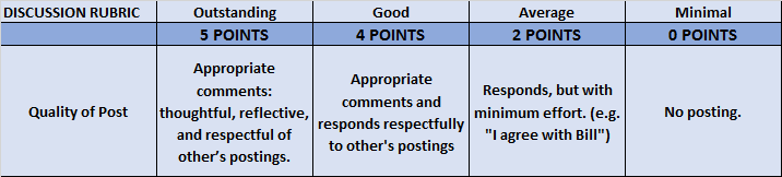
4. Online Discussion: Answer Chapter 1 Review Questions 1, 2, 3, and 6 listed on page 25. Post your answers to the Module 2 Discussion link on Moodle. After you make your post, reply to at least two other posts, stating why you agree or disagree with their answers - please be considerate and respectful. Per any suggestions received, you may change your answers as long as the change(s) are made before Sunday at 11pm. (10 points total: half (5 points) are discussion points per the Discussion Rubric provided, the other half (5 points) are awarded for correct answers. 10 points total: half (5 points) are discussion points per the Discussion Rubric provided below, the other half (5 points) are awarded for correct answers – 1.25 points for each correct question answered.
Discussion Rubric:
Module 2 Overview Video
Instructor
Instructor: Mike Ribant
Instructor Email: mribant@ccc.edu
Mike Ribant M.A.; A.B.D., is a doctoral candidate in the Department of Geography at Northern Illinois University, where he has taught geography and was named Outstanding Graduate Student. For the past several years, Ribant has taught classes in Geographic Information Systems (GIS) and geography at various colleges in the Chicagoland area including Northeastern Illinois University, Northern Illinois University, Harper College, Triton College and City Colleges of Chicago. These classes include Introduction to GIS, Advanced GIS, Interactive Cartography, Remote Sensing, Vector GIS and Raster GIS. Ribant also developed a course for Chicago State University under a grant contract entitled GIS for Homeland Security and won the poster competition at a recent Illinois GIS Association (ILGISA) conference. He currently teaches at Harper College and Harold Washington College in downtown Chicago. His research interests are in the areas of urban geography, GIS, web mapping, spatial analysis, transportation geography, public finance and geovisualization. A native Detroiter, his dissertation research aims to better understand America’s post-industrial, shrinking cities and examines various operationalized and postulated methods for ”right-sizing“ them. Prior to entering graduate school in 2007, Ribant owned a retail coffee chain in downtown San Diego. An avid fly-fishing enthusiast, Ribant is the editor of two books about fishing: The U.S. Bass Atlas and The U.S. Trout Atlas.